Surveying is a rapidly developing profession that focuses on the location of various land use rights and the boundaries between them. Consequently surveying is often considered to be a quasi-judicial profession. Like most professional fields, surveying is grounded in the sciences, notably the sciences of mathematics and measurement theory. Perhaps to a greater extent than many other professions, surveying is being rapidly affected by new technological changes, such as Computerized Mapping, Geographic Information Systems (GIS), Global Positioning Systems (GPS), Robotics, Scanning, and Wireless Communications.
Surveyors use a variety of tools and skills in their every day work. Due to technological advances, Surveyors now use the most state-of-the-art satellite and scanning technologies: computers, drones, a knowledge of geometry, statistics and trigonometry, and a thorough grounding in our legal system and how it operates in relation to land ownership issues. The Bachelor of Science in Surveying and Mapping Science at ETSU is designed to prepare students for this important work.
Meet Surveying Student ~ Luis Mora
ETSU Advantage
Academic Common Market:
The Surveying and Mapping Science program is part of the Academic Common Market agreement with Alabama, Kentucky, Mississippi, South Carolina, Virginia, and West Virginia. Residents in these states, as well as those in the border counties of North Carolina, may be eligible for in-state tuition rates.
Flexible Learning Experience:
The program offers a flexible online learning experience. Most of the program’s classes are video-streamed live so that students who cannot always come to campus can take courses from a distance.
Premier Accreditation:
The Bachelor of Science degree in Surveying and Mapping Science program in the Engineering, Engineering Technology, Interior Architecture, and Surveying is accredited by the Applied and Natural Science Accreditation Commission of ABET, https://www.abet.org, under the General Criteria.
ABET is the premier accrediting organization of applied science, computing, engineering, and engineering technology programs in the United States.
Professional Surveying License:
ETSU's Surveying and Mapping Science program offers a degree that’s accepted as the educational foundation for the Professional Surveying License throughout the United States.
Therefore, the degree meets or exceeds the minimum educational requirements for surveying licensure in most states and many foreign jurisdictions. Prospective students should check the licensure requirements of every specific state of interest as professional licensure requirements vary from state to state. In addition to education requirements for licensure, most states also have work experience and examination requirements that must be met before a license to practice surveying will be granted.
- Survey and Mapping Sciences Facts:
-
- In 2019, for two consecutive years, the Surveying and Mapping program received educational awards totaling $25,000 from the National Council of Examiners for Engineering and Surveying (NCEES).
- Most students in ETSU's Surveying and Mapping Science program graduate with multiple job offers in the discipline.
- The job demand for Surveyors continues to grow. The U.S. Bureau of Labor and Statistics
projects employment of surveyors to grow 11% from 2016 to 2026 due to expected increases
in construction and the rising average age of current professional surveyors.
While the overall job opportunities are expected to be good, those with knowledge of a variety of surveying specializations and a bachelor’s degree from an ABET – accredited school will have the best job opportunities.

Program Overview
-
Expectations
Our students come to us with a wide variety of backgrounds, interests, and talents. No one generalized statement will fit everyone. So perhaps the best answer to the question of what to expect as a surveying graduate is to answer in the negative; what not to expect.
Surveying graduates are not master technicians or crew chiefs. While many of our students acquire mastery of surveying technology before coming here, and while all of our students should have some basic familiarity with various surveying technology and theory, they will need more practice and instruction with surveying technology. For example, please know that a typical four-credit course gives a student approximately the same amount of lab time as 2 weeks of full-time employment.
At ETSU, we believe that the best way to prepare students for service as future professionals is through a partnership between education and employment. We see the role of the educational institution as exposing the students to the breadth necessary to see all the opportunities before them, both personally and professionally. We see the role of the employer as providing the depth needed to master the opportunities that they decide to pursue.
This means that our graduates won’t leave ETSU knowing all that is needed to know as a professional surveyor. Although they will have been exposed to a great deal of theory, they are not expected to be a master of it. Although they will have written many papers, given oral presentations, performed field work, prepared maps and done a host of other assignments while at ETSU, they will not have been given enough exposure to any one thing to have mastered everything. But, by the time they graduate they should know how to learn. And they will still have much to learn.
-
Program Objectives & Student Outcomes
1. An ability to communicate effectively with a range of audiences.
2. An ability to develop and conduct experiments or test hypotheses, analyze and interpret data and use scientific judgment to draw conclusions.
3. An ability to formulate or design a system, process, procedure, or program to meet desired needs.
4. An ability to function effectively on teams that establish goals, plan tasks, meet deadlines, and analyze risk and uncertainty.
5. An ability to identify, formulate, and solve broadly-defined technical or scientific problems by applying knowledge of mathematics and science and/or technical topics to areas relevant to the discipline.
6. An ability to understand ethical and professional responsibilities and the impact of technical and/or scientific solutions in global, economic, environmental, and societal contexts.
7. Successfully Complete the National Council of Examiners for Engineering and Surveying (NCEES) Fundamentals of Surveying (FS) exam.The objective of the Surveying and Mapping Science Program is to prepare graduates to successfully pursue their professional career objectives in a land surveying and mapping-related field. The Program considers this objective to be realized if a majority of graduates:
1. Analyze, manage, and disseminate geospatial data utilizing industry standard land surveying techniques.
2. Are employed in a field within the geomatics disciplines.
3. Continue professional education by participating in professional development courses or sessions, or complete higher education courses.
4. Have successfully completed licensing for professional certification/registration, e.g. PS, CP or GISP, as appropriate for their career path in a geomatics discipline.
5. Obtain membership in one or more professional organizations relevant to their career of choice. -
Program Outcomes:
1. An ability to communicate effectively with a range of audiences.
2. An ability to develop and conduct experiments or test hypotheses, analyze and interpret data and use scientific judgment to draw conclusions.
3. An ability to formulate or design a system, process, procedure or program to meet desired needs.
4. An ability to function effectively on teams that analyze risk and uncertainty, establish goals, meet deadlines, and plan tasks.
5. An ability to identify, formulate, and solve broadly-defined technical or scientific problems by applying knowledge of mathematics and science and/or technical topics to areas relevant to the discipline.
6. An ability to understand ethical and professional responsibilities and the impact of technical and/or scientific solutions in economic, environmental, global, and societal contexts. -
Program Educational Objective:
The objective of the Surveying and Mapping Science Program is to prepare graduates to successfully pursue their professional career objectives in a land surveying and mapping-related field. The Program considers this objective to be realized if a majority of graduates:
1. Are employed in a field within the geomatics disciplines.
2. Have applied skills, conducted themselves ethically and professionally, and exhibited personal integrity and responsibility in surveying practice.
3. Have collected, analyzed, managed, and disseminated geospatial data utilizing industry standard land surveying techniques.
4. Have continued professional education by participating in professional development courses or sessions, or complete higher education courses.
5. Have obtained membership in one or more professional organizations relevant to their career of choice.
6. Have shown proficiency in using surveying equipment and gathering surveying data for the use of analytical and problem-solving skills reasonably expected for surveying practice and necessary to be in responsible charge of surveying operations.
7. Have shown proficiency in written, oral, and graphic communication to deal with promotion of professional services, business communications, reporting to clients, interacting with peers, and addressing client matters in public forums.
8. Have successfully completed the necessary requirements for certification, professional licensure, or registration as appropriate for their career path in a geomatics discipline.
Surveying Students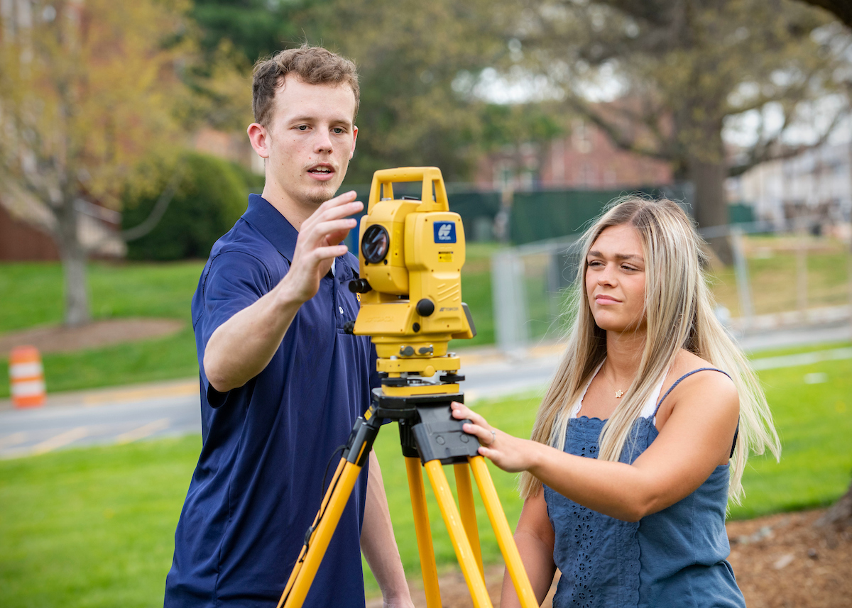
Curriculum
To graduate from ETSU with a degree in Surveying and Mapping Science a student must complete a total of 128 hours. These hours are broken down as follows:
- General Education (42 credit hours)
Guided Electives (12 credit hours)
Surveying and Mapping Science Technical Core Requirements (74 credit hours)
A list of these classes and a course description of each can be found in ETSU’s on-line catalog.
-
General Education
- ENGL 1010 Foundations in Writing
- ENGL 1020 Written Communication & Critical Thinking
- Oral Communication (choose 1)
- Literature (choose 1)
- Fine Arts Elective (choose 1)
- ENTC 3020 Technology & Society
- Social and Behavioral Sciences (choose 2)
- HIST 2010 The United States to 1877
- HIST 2020 The United States since 1877
- MATH 1530 Probability and Statistics – Non-calculus
- PHYS 2010 General Physics I Non-calculus
- PHYS 2011 General Physics Laboratory I Non-calculus
- PHYS 2020 General Physics II Non-calculus
- PHYS 2021 General Physics Laboratory II Non-calculus
- CSCI 1100 Using Information Technology
-
Surveying & Mapping Major Core
- SURV 1550 - Introduction to Surveying
- SURV 1570 - Portfolio I
- SURV 2520 - Introduction to Surveying Law
- SURV 2550 - Surveying Measurement Fundamentals
- SURV 2560 - Surveying Graphics
- SURV 3510 - Engineering and Construction Surveys
- SURV 3525 - Introduction to Unmanned Aircraft Systems (UAS)
- SURV 3530 - Survey Measurement and Computational Analysis
- SURV 3540 - Junior Surveying Projects (2 credits)
-
*Note: This course is offered during the summer terms and must be taken 3 times at 2 credits per session for a total of 6 credits.
- SURV 3550 - Advanced Surveying Mathematics
- SURV 3560 - Geodetic Science
- SURV 3570 - Photogrammetry
- SURV 3580 - Surveying Topics
- SURV 3630 - Surveying Hydrology I
- SURV 4500 - Senior Surveying Projects
- SURV 4537 - Land Boundary Location
- SURV 4547 - Land Subdivision and Platting
- SURV 4550 - Automated Surveying and Mapping
- SURV 4567 - Positioning with GNSS
- SURV 4570 - Portfolio II
- SURV 4617 - Digital Mapping
- GEOS 3500 - Geographic Information Systems
- ENTC 3030 - Technical Communication
- MATH 1530 - Probability and Statistics – Non-calculus
- MATH 1710 - Precalculus I (Algebra)
- MATH 1720 - Precalculus II (Trigonometry)
- Advisor Approved Electives: 6 credits
-
Six (6) credits must be taken from an approved list on file with the department. No course on the list can be double counted toward a disciple core course or General Education requirement. Students are expected to package these electives together in a way that fits their unique career goal.
Choose from:
- ACCT 2000 - Accounting for Nonbusiness Majors (3 credits)
ACCT 2010 - Principles of Accounting I (3 credits)
ASTR 3415 - Astrophysics (3 credits)
COBH 2030 - First Aid and Emergency Care (3 credits)
COMM 3310 - Intrapersonal Communication Processes (3 credits)
COMM 3380 - Communicating in Groups (3 credits)
COMM 3390 - Persuasion (3 credits)
COMM 4346 - Business and Professional Communication (3 credits)
COMM 4350 - Organizational Communication (3 credits)
COMM 4356 - Intercultural Communication (3 credits)
CSCI 2020 - Fundamentals of Database (3 credits)
CSCI 2100 - Introduction to C (3 credits)
ENTC 1110 - Engineering Drawing (4 credits)
ENTC 2038 - Honors Professional Ethics (3 credits)
ENTC 2060 - Project Scheduling (3 credits)
ENTC 2160 - Architectural CADD (3 credits)
ENTC 2170 - CADD (Computer Aided Design Drafting) (4 credits)
ENTC 2410 - Construction Fundamentals (4 credits)
ENTC 2420 - Construction Documents and Planning (4 credits)
ENTC 3010 - Statics and Strength of Materials (4 credits)
ENTC 3020 - Technology and Society (3 credits)
ENTC 3400 - Construction Materials (4 credits)
ENTC 3410 - Construction Estimating and Planning (4 credits)
ENTC 3420 - Advanced Construction Estimating and Planning (4 credits)
ENTC 3430 - Materials and Methods I (4 credits)
ENTC 3620 - Thermal and Fluid Technologies (4 credits)
ENTC 4227 - Engineering Economy (3 credits)
ENTC 4417 - Construction Financing and Administration (3 credits)
ENTC 4440 - Structural Steel and Timber (3 credits)
ENTC 4777 - Safety Management (3 credits)
ENVH 3040 - Environmental Sanitation (3 credits)
ENVH 3100 - Water Supplies and Wastewater Treatment (3 credits)
ENVH 3700 - Solid Waste Management (3 credits)
FNCE 3120 - Principles of Real Estate (3 credits)
FNCE 3130 - Real Estate Law (3 credits)
FNCE 4350 - Real Estate Management (3 credits)
GEOS 1040 - Geosciences: Earth and Society Lecture (3 credits)
GEOS 1041 - Geosciences: Earth and Society Laboratory (1 credit)
GEOS 2500 - Digital Mapping with GIS (3 credits)
GEOS 3090 - Meteorology and Climatology (4 credits)
GEOS 3481 - Natural Hazards and Society (3 credits)
GEOS 3600 - Remote Sensing (3 credits)
GEOS 4200 - Soil, Geosciences, and Mechanics (3 credits)
GEOS 4237 - Advanced Remote Sensing (3 credits)- GEOS 4317 - Advanced Geographic Information Systems (3 credits)
- GEOS 4587 - Engineering Geology (4 credits)
GEOS 4617 - Structural Geology (4 credits)
MATH 2050 - Foundations of Probability and Statistics - Calculus Based (3 credits)
MGMT 3000 - Organizational Behavior and Management (3 credits)
MGMT 3310 - Legal Environment of Business (3 credits)
MKTG 3200 - Principles of Marketing (3 credits)
PHIL 3050 - Symbolic Logic (3 credits)
PHIL 3150 - Philosophy of Law (3 credits)
PHIL 4017 - Ethical Theory (3 credits)
PMGT 3100 - Introduction to Urban and Regional Planning (3 credits)
PMGT 4107 - Urban Geography and Planning (3 credits)
PSCI 3200 - Law and Judicial Process (3 credits)
SURV 4957 - Special Topics in Surveying and Mapping Science (1-6 credits)
Enrollment and Graduation Data
| Academic Year |
Enrollment Year 1st, 2nd, 3rd, 4th |
Total Undergraduate | Degrees Awarded (Bachelors) |
| 2018-2019 |
FT: 15, 7, 8, 5 |
FT: 33 |
7 |
| 2017-2018 |
FT: 10, 7, 6, 5 |
FT: 26 |
7 |
| 2016-2017 |
FT: 8, 9, 6, 7 |
FT: 34 |
12 |
| 2015-2016 |
FT: 8, 8, 5, 7 |
FT: 31 |
9 |
| 2014-2015 |
FT: 11, 10, 6, 5 |
FT: 31 |
4 |
Club |
Employers |
Career Opportunities
|
|
The students at ETSU have formed a student organization dedicated to helping the students enrolled in the Surveying and Mapping Science program degree. Any student at ETSU is eligible to join this club. The Surveying Club at ETSU is a valuable resource for the surveying students at ETSU and we strongly recommend that every surveying student join the club and actively participate in it. Club activities can include:
|
There are several paths to locating the right employee to match your firm’s needs. One path is through a resume book published by our student surveying club. Several of our students have taken the initiative of preparing their resumes and publishing them in this book. This book is typically published each January. If you would like a copy of it, send an email to the Program Coordinator. Although the students who have placed their resumes in this book are some of our most organized and attentive, you may find that no one listed in the resume book adequately meets your firm’s needs, or that no one remains available by the time you are ready to make a hire. In either event, other alternatives are available. One direct path that is available to you is to make a direct posting of your needs to our student e-mail list. We maintain an email list of all surveying majors, as well as some alumni, faculty and other interested people. All prospective employers are invited to submit an announcement of any employment opportunities they may have. That announcement will be forwarded to everyone on the list, usually within 24 hours. If you would like to post an employment opportunity to the list, you can send it directly to surveyors@listserv.etsu.edu. |
Graduates may use their surveying skills in a variety of industries, such as aerial mapping and photogrammetric firms, land development and real estate companies, and engineering and private surveying firms. Still others may seek opportunities in local, county, state, and national government in areas such as GIS and land record agencies, public works, the U.S. Corp of Engineers, or U.S. military branches. Some common career paths for Surveying and Mapping graduates include:
An undergraduate degree in Surveying and Mapping Science also provides a good foundation for graduate study in fields such as: - Cartography |
Faculty

Dr. Jin Hong
Associate ProfessorEngineering, Engineering Technology, Interior Architecture & Surveying
- hongjs@etsu.edu
- (423) 439-7701
- 112A Wilson-Wallis Hall

Peter Messier
Professor of PracticeEngineering, Engineering Technology, Interior Architecture & Surveying
- messierp@etsu.edu
- (423) 439-2292
- 002A Wilson-Wallis Hall

Jared D. Wilson
Program Coordinator; Assistant ProfessorEngineering, Engineering Technology, Interior Architecture & Surveying
- wilsonjd@etsu.edu
- (423) 439-8208
- 208 Wilson Wallis Hall
Industrial Advisory Committee
| Ford Baker | Adam Leftwich | Chris Pappas |
| Joe Bidwell | Matthew Lindvall | Patrick Peterson |
| Casey Hayes | Tim Lingerfelt | Anthony Suttle |
| Jin Hong | Rod McCarter | Floyd Sweat |
| Dave Ingram | Peter Messier | Charles Whittenburg |
| Keith Johnson | Benjamin Mooreman | Tommy Young |